Thurston Peak lies to the north of Francis Peak, site of an air radar installation. To get to Thurston, the easiest approach is from Francis Peak, north just a bit along the ridge line. Having gotten a look at the ridge line, however, I’m thinking that hike is no cakewalk. The ridge line is rugged, gaining and losing decent altitude at every lesser peak. In the winter, the road to Francis is closed due to snow. Many winters sees this road as a popular snowmobile destination, but this winter in Utah has been almost snowless - the snow line this weekend was right around 7500 feet or higher. I have to admit, if there were more snow I might have asked for a lift to Francis so I could tackle both peaks!
The morning started early, with a 5:45 am “BOG” trail time (boots on the ground). Knowing I’d be crossing a snow field, I had to pack a fair amount of gear - snowshoes, hiking poles, and an ice axe. Unlike most trips, I used every piece fo gear I brought.

The trail begins at the Fern Hollow trail head, which is reached by taking SR 89 to the Cherry Street intersection. From the parking lot, head east up the trail. Some people take the direct route straight up the hill, but I prefer to follow the trail east, on the south side of the hill, and then back up from the east side of the ridge. Regardless of the approach, eventually you end up on an east-west ridge due east of Antelope Drive, which is the north ridge of the "Middle Fork Hobbs Creek" canyon. I hope you enjoy the view, because you’re on this ridge for a long time!

Looking down from the ridge
As you climb, the ridges just keep coming. There are three or four of them, progressively more north of each other. The going is tough - you’ll climb roughly 4000 feet in less than 3 “horizontal” miles.

I call this the "Lunch Counter". Great view for a snack and a rest.
Eventually you'll clear the ridge and end up solid on the west face of the north south ridgeline. At this point, you've got options: continue due east to pick up elevation, or start to head south/southeast to draw closer to Francis Peak. On my trek this weekend, I made a slight route finding error, heading south around the final ridge. This put me at the base of a narrow, steep avalanche chute. The snow conditions were tough in this chute--alternating between crusted and soft, so I ended up breaking through the crust every other step. It was quite exposed, so I retreated west as I climbed up out of it. It cost a fair amount of time and a lot of energy. Lesson: don't head south until you've cleared the final peak on the Hobbs Creek Middle Fork ridge.

Wind-loaded snow conditions
As I write this blog, we're receiving 6" to 12" of snow in the valley, so the snow conditions yesterday are irrelevant. But crossing south along the face just below the ridge line was consistent: wind-loaded, crusty, cupped snow. Ideal for climbing, although at times I felt a bit over-exposed. I was climbing on MSR snowshoes with an alpine ice axe. I think I'd have been more comfortable either in crampons or roped up with a buddy.

Close up of crusted, wind-loaded, cupped face.
I routed several hundred feet below the ridge, for maybe a mile or two from the middle fork Hobbs creek to the Thurston Peak ridge proper. Thank heaven for glacier glasses, too. Once the sun broke over the ridge, it was bright and nearly directly head on.

First Glimpse of Summit
After traversing south below the main ridge, the last effort to the summit is a pretty big hump due east up the Thurston Peak ridge. I selected this route because the actual north-south ridge looked pretty rugged and I wasn't sure of the snow conditions. On the return route, I stayed closer to the ridge line because the entire traverse to the south I felt really exposed, and it just got worse climbing that last hump to the summit. The ridgeline route cut off a good 15 min on the way back.

This is what feels like to summit

This is what it takes to get there (and back). I promise - my battery died the moment I walked in the door. No extra steps counted.

Plaque explaining who Thomas Jefferson Thurston was

360-degree view

My SOTA Setup
I learned my last hike when I hit Frary Peak that, as excited as I might be to "play radio," it's important to take care of myself first. Frary is a forgiving hike, frequented by lots of hikers. Thurston? I reckon to be one of a handful who summit this peak all winter. There was no room for mistakes like failing to hydrate, eat, or put on extra clothes.

This video shows why taking care is important - the wind was blowing at a good 20 mph. The wind chill factor was enough that exposed skin was frosted in seconds.

Setting up the KX3

One guy line for the Buddistick

I buried the hiking stick in snow, and set the ice ax in front of it for stability. With the wind blowing as it was, only two guy lines were necessary.
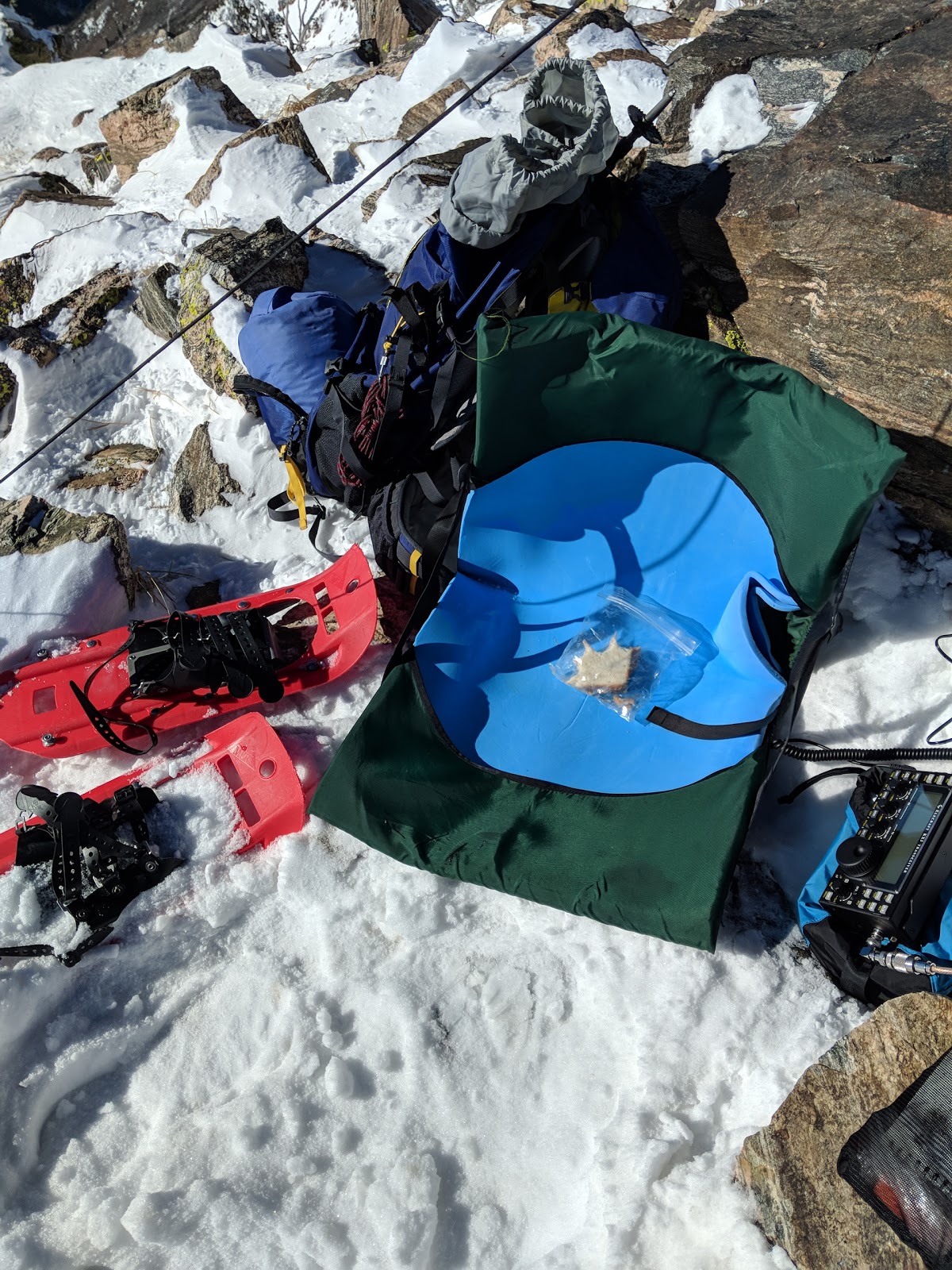
SOTA base station - KX3, Thermarest chair with closed-cell foam.
 h
h
Buddistick set up, leaning against the wind. The Ogden Valley is in the background. The backpack was a wind shelter.
I'm learning SOTA activations go fast. As soon as I set up, I called CQ and was picked up by my buddy WB6YOK (whose QTH is about a mile due south of Thurston. I couldn't self-spot on the SOTA app, so Chuck spotted me. After that, I had 11 solid QSOs in 20 minutes, and then activity just dropped to nothing. My activator log:
| Time | Call | Band | Mode | Notes |
|---|---|---|---|---|
| 18:05z | WB6YOK | 14MHz | SSB | Groundwave |
| 18:05z | WB7ULD | 14MHz | SSB | Groundwave |
| 18:08z | W5ODS | 14MHz | SSB | 58 into OK |
| 18:10z | N4EX | 14MHz | SSB | 44 into NC |
| 18:11z | WD9F | 14MHz | SSB | 55 into IL |
| 18:12z | WA2USA | 14MHz | SSB | 55 into IN |
| 18:17z | KD0YOB | 14MHz | SSB | 57 into MN |
| 18:18z | K8HU | 14MHz | SSB | 59 into VA |
| 18:18z | AK5SD | 14MHz | SSB | 45 into TX |
| 18:19z | WB0KIU | 14MHz | SSB | 56 into IA |
| 18:20z | AB5V | 14MHz | SSB | 47 into TX - Randy |
| 18:21z | K0LAF | 14MHz | SSB | 33 into MO |
Signals were varied, but this is my second SOTA activation and both times have had strong signals into the East, with VA being the best signal of the day. It was great chatting with Randy AB5V in Magnolia, TX who is a SOTA activator himself. I had several SOTA chasers on this activation, which is great.
With the bands settling quickly, I packed up and made my way out quickly. A couple mountaineering quips serve me well on each climb. First, as my friend and climbing partner Fredito KE7JVA says, there are old climbers, there are bold climbers, but there are no old, bold climbers. Caution is the mother of safe arrivals. Second is that the majority of mountaineering incidents happen on the way home. Climbers often forget they need as much energy to get down safely as it takes to get up to the summit. Once I was packed up, I took a moment to center myself. On the way up, I decided I wanted to return a different route, due to the excessive exposure. Had I been wearing crampons, it would have been a different story and I'd have gone back the same way. Rather, I decided to head north up the ridge, climbing down a steep rock section, skirting a nearby summit by traversing to the west through trees, then heading across the snowfield. I stayed much higher on the return route, eventually meeting up with the ridgeline prior to heading west into the Middle Fork Hobbs Creek drainage.
One mistake I made on this trip was to switch from my extra large Nalgene bottle to my CamelBak. They have the same capacity, but the CamelBak tube froze up at the summit, and I had to hike for a solid hour before I could thaw it enough to drink. By then, I felt the dehydration.
The hike home is just a repeat of the hike up - step by step, watch the ice, watch the mud. As I age, my knees get sore on the way down, so it's all about tender steps. It underscores the need to travel light.
A hike like this is roughly the equivalent of hiking from Paradise to Camp Muir, Mt. Rainer's staging site for a final summit attempt. Each time I pull off a hike of this magnitude, I say the same thing: "never again, not for several years," but sitting in my armchair writing this blog, I'm already thinking about what the next peak will be.


